ePrivacy and GPDR Cookie Consent by Cookie Consent
register at Windows8Downloads.com Windows 8 Downloads RSS add Windows 8 Downloads to favorites

Panoply - Windows 8 Downloads

Panoply

Panoply 5.2.7

Panoply NETCDF, HDF and GRIB data viewer
Panoply is an utility that enable user to plot raster image. Depending on the data, it can draw global longitude-latitude images or pole-to-pole latitude-vertical images.

Panoply 5.2.7 - Key details

Panoply screenshot
PanoplyCADWindows XP, Windows Vista, Windows Vista x64, Windows 7, Windows 7 x64, Windows 8, Windows 8 x64, Windows 10, Windows 10 x64, Windows 11

User Rating: 2.0 (3 votes)

License: Freeware
Price: FREE
File Size: 34.00 MB
Released:
Downloads: Total: 124 | This Week: 6
Keywords: plot raster image, longitude image, pole-to-pole image, raster image, rasterize, raster
Author:
Author URL: https://www.giss.nasa.gov/
Panoply x32 Panoply x64

Windows 8 Downloads - Panoply awards
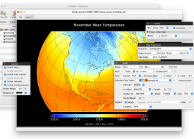
Panoply Windows 8 compatible Windows 8 download editor's pick

Panoply - Full description

Panoply is an utility that enable user to plot raster image. Depending on the data, it can draw global longitude-latitude images or pole-to-pole latitude-vertical images.Panoply is a cross-platform application which plots geo-gridded arrays from netCDF, HDF and GRIB datasets.

Panoply for Windows 8 - Post your review

Your Name:
Product Version:
Rating:
Review:
Security Code:

Panoply Windows 8 related downloads

... & save GPS route and View and Rectify Raster Images gif, jpg, bmp and Edit shape files, build new layer, ...
R2V
R2V is a tool for converting raster images to vector by drawing centerlines and outlines. R2V ... various technical drawings, maps and other types from raster to vector format. A vector format can be ...
... to Image, DXF to Image and DWF to Raster Image directly without need of AutoCAD, it converts DWG, DXF and DWF files into Raster Image files, quick and easily. Key Features Batch convert ...
... Seismic survey conversion · Vector data conversion · Raster format support · Georeferencing - reference point selection · Raster reprojection ...
... to Image, DXF to Image and DWF to Raster Image directly without need of AutoCAD, it converts DWG, DXF and DWF files into Raster Image files, quick and easily. Key Features Batch convert ...
... new modeling techniques for modeling artistic shapes using raster bitmap images. Used in conjunction with VisualCAM's 3D modeling tools, it ...
... Open Source Software (FOSS). QGIS supports vector, raster, and database formats and lets you browse and ... data viewing needs. QGIS supports a number of raster and vector data formats, with new support easily ...
... some key features of Triangulatica: - Vector & raster slicing in one application; - Unique method of ... for layers with parametric fillings. 4. Vector & raster slicing Triangulatica generates layers in large amount of ...
... convert and markup Gerber, HPGL, HPGL/2, Excellon and raster files. GerbView supports both RS274D and RS274X (with ... list of supported formats below. GerbView can rasterize single files, or whole workspaces, and save to ...
... convert and markup Gerber, HPGL, HPGL/2, Excellon and raster files. GerbView x64 supports both RS274D and RS274X ... of supported formats below. GerbView x64 can rasterize single files, or whole workspaces, and save to ...

Advertise Link To Us Privacy Policy Contact Us