


NTv2Poly - Windows 8 Downloads

NTv2Poly 7.00
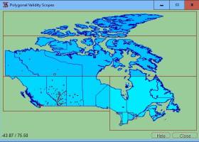
Discover NTv2Poly, a powerful software for Windows 8 that allows you to seamlessly convert NTv2 grid files into polygon shapefiles. Enhance your geospatial data processing with this innovative tool.
NTv2Poly 7.00 - Key details
| License: | Shareware |
|---|---|
| Price: | $185.00 |
| File Size: | 10.55 MB |
| Released: | Jan 1, 2024 |
| Downloads: | Total: 38 | This Week: 0 |
| Keywords: | outline, shape, ntv2poly, software, NTv2, validity, scopes, page, insert, Killet GeoSoftware Ing.-GbR, concise, review, outlines, polygonal, polygon, inserting, creative, scope, killetsoft, shapefile, NTv2Poly, binary, file |
| Author: | Killet GeoSoftware Ing.-GbR |
| Author URL: | https://www.killetsoft.de/ |
  |
Windows 8 Downloads - NTv2Poly awards

NTv2Poly - Full description
Welcome to the ultimate destination for Windows 8 software downloads! Discover the remarkable "NTv2Poly" developed by Killet GeoSoftware Ing.-GbR. This cutting-edge software empowers you to effortlessly convert NTv2 grid files into polygon shapefiles, streamlining your geospatial data processing. With its user-friendly interface and unrivaled precision, NTv2Poly is an indispensable tool for professionals and enthusiasts alike. Embrace the future of geospatial data conversion with NTv2Poly, available exclusively on our website.
NTv2Poly for Windows 8 - Post your review
NTv2Poly Windows 8 related downloads
This software offers a solution to users who want to ... individually or load a set from a text file. The application displays the results in a list, ...
NTv2Creator geosoftware provides a powerful tool for modelling accurate NTv2 files from identical points in two different Reference Systems. The software analyses two files with identical points and suggests ...
... Create and edit waypoints, tracklogs, routes, and insert scanned images of map. More than 160 GPS ... on the map image ! Makes possible to insert several scanned map images in the background True-Grid ...
... change all formulas as desired, directly in the software. All in all, 21st century worldwide growth of ... Nature developments and it's based on the reliable software platform of Dynamic Applications. ...
Get the world’s geographic information at your fingertips Take a virtual journey to any location in the world. Explore 3D ...
Enigeo is a great way to learn countries, capitals and flags around the world in a fun way. You can either ...
Commonly referred to as GRASS, this is a free Geographic Information System (GIS) used for geospatial data management and analysis, image ...
... making it easier for geocachers to process GPX files and publish them on their GPS devices. ... Automatically copy cache photos to Garmin GPS devices. Review loaded caches on Bing Maps or in a ...
... manager (import and export of GPX and KML files, track conversion, track design, track editor) Favourites database with support for ...
UTM Coordinate Converter, converts between various geographic coordinate systems, allowing you to convert between various Latitude/Longitudes systems and the Universal Transverse ...
Windows 8 Coupons
-
IObit Uninstaller
35% Off -
FREE VPN PROXY by SEED4.ME WINDOWS
Free VPN by Seed4Me -
Driver Booster
35% Off -
MacX DVD Video Converter
58% Off -
IObit Malware Fighter
35% Off
Saved Downloads
You have not saved any software.
Click "Save" next to each software.
Click "Save" next to each software.
Would you like to receive announcements of new versions of your software by email or by RSS reader?
FREE Registration Here!
Win8 Download Picks
Top Win8 Downloads
- FastSatfinder
- Advanced Trigonometry Calculator Portable
- Orbit Simulator
- STL Tracker
- Google Earth
- RealMeteo Portable
- Free Google Translate Desktop
- Portable Balabolka
- Typing Tutor Hindi Mangal Gail
- Oxford Dictionary of English
- ANOP ENGLISH TYPING TUTOR
- Typing Exam Hindi Remington Gail
- Grammar Checker Ginger for Safari
- Stellarium for Windows (x64 bit)
- Kruti Dev Font Typing Master